 |
| You look like ants from way up here! |
Peak 51 [1150 feet, Houston County]: From I-90, take CR 43 south through Rushford to 16. Head east on 16 to the country club driveway (the only safe place to park). The hill is between house numbers 23148 and 23740 on private property. The approach from the south is posted No Trespassing. From the north, a scramble is possible, but not much fun.
 |
| One new structure on this property, several like this one. |
Peak 52 [1121 feet]: Peak is at the intersection of property owned by three different people. It took a lot of time to find the absentee landowner of this property and the one across the street (#10968). The photo below is deceiving; the peak is to the left of the property line and crops and a good way back into the trees. It probably looks impressive from the park on the opposite side of the river.
 |
| No, I didn't hit a cow. Deer are bad enough. |
Peak 53 [1110 feet]: In Frontenac State Park, go to the end of the Group Camp site, bushwhack 1/4 mile to the sign that tells you that, yet again, it's private property. This peak was more difficult than expected, as the GPS compass just spun wildly and I had to go by feel and memory of maps. There were a huge number of turkeys and a dozen different species of butterflies.
The peak is 100 yards into a corn field.
 |
| Best to get permission before planting or after harvest. This is the nearest legal view. |
Not far from here is the natural feature In Yan Teopa ("Rock With Opening"), which gives the name to the 10 Mile trail race held here each autumn. Always worth a look:
 |
| In Yan Teopa |
From the park, I drove north on 61 toward Red Wing. The next two peaks are surprisingly close. Just south of town, turn right on Sevastopol (277th Ave), take the turn at Gadient (267th), then onto Bayview. The peak is on private property at #28023, right at the property line - which allows a fast unseen dash through neighboring private property to the top.
Back on Hwy 61, head into Red Wing and you'll drive past the next peak, Barn Bluff, on Main Street. Finding the access is not obvious.
Peak 55: Barn Bluff [1010 feet]
 |
| View from the levee, from which there's no access. |
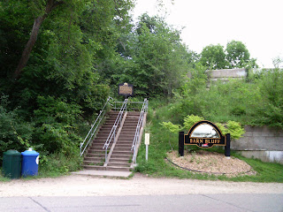
From Main Street (Hwy 61), turn away from the river on almost any street (Plum's a good choice), then hang a left on 5th and head east to the access:
 |
| There's a lot of stairs; you'll appreciate the ones near the top. |
 |
| The North Trail had a lot of climbers. This woman had an odd accent, which I decided was from New Hampshire. |
I expect most people believe the top of the peak is at the marker at the top of the stairs, but one has to follow the Prairie Trail to the East Lookout.
 |
 |
The true high point is 100 yards from the lookout at the edge of a cliff. It's a bit unnerving.
 |
| The actual high point. The trees are on the face of a cliff. |
 |
| Another view, to the south. |


3 comments:
This is a cool idea! How many of the highest spots are there in all?
And my mom hit a black cow in the dark on the highway once. Five years, two back surgeries, and lots of chiro and PT visits later, she's still hurtin'. Yeah, don't hit cows.
Still loving this idea of yours. I would so love to visit your country.
What a fun weekend, Steve! Glad no one chased you off their property with a gun - you know I'm from Texas, and that's allowed :)
Post a Comment